Vallecito Dam Construction Project
Pages
-
-
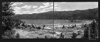
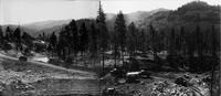
Panorama of damsite looking upstream (5)
-
Panorama of dam looking upstream from a point on the right abutment about 1/4 mile downstream from axis. (Photographic point No. 2). Refer to Pine R - 248 a&b (D003009)., Original photo number: Pine R - 245 a&b
-

-
Panorama of damsite looking upstream (6)
-
Mosaic of dam looking upstream from a point on the right abutment about 1/4 mile downstream from axis. (Photographic point No. 2). Refer to Pine R - 248 a&b (D003009) and Pine R - 322 a&b (D003010)., Original photo number: Pine R - 026
-
-
Panorama of left abutment (left)
-
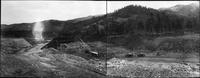
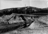
Panorama of left abutment after clearing and stripping. Dragline is cleaning up preparatory to placing embankment in permanent cofferdam. Embankment seen in 82a is temporary cofferdam from waste material. Gravelly material on left bank is being used in inverted filter. Tripod supports sump pump. Taken from point 300 feet upstream from station 13+00., Original photo number: Pine R - 059
-
-
Panorama of left abutment (right)
-
Panorama of left abutment after clearing and stripping. Dragline is cleaning up preparatory to placing embankment in permanent cofferdam. Embankment seen in 82a is temporary cofferdam from waste material. Gravelly material on left bank is being used in inverted filter. Tripod supports sump pump. Taken from point 300 feet upstream from station 13+00., Original photo number: Pine R - 059
-
-
Panorama of river channel (1) (left)
-
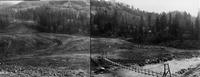
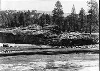
Panorama of river channel looking downstream from top of cofferdam at sta. 11+30. Cut-off trench excavation in foreground. Note sand deposits on each bank of river., Original photo number: Pine R - 074
-
-
Panorama of river channel (1) (right)
-
Panorama of river channel looking downstream from top of cofferdam at sta. 11+30. Cut-off trench excavation in foreground. Note sand deposits on each bank of river., Original photo number: Pine R - 074
-
-
Panorama of river channel (2) (left)
-
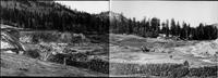
Panorama of river channel looking downstream from the top of the cofferdam, station 11+25, showing sand deposit to the right and left of river channel. Refer to Pine R - 120 a, b, & c., Original photo number: Pine R - 088
-

-
Panorama of river channel (2) (right)
-
Panorama of river channel looking downstream from the top of the cofferdam, station 11+25, showing sand deposit to the right and left of river channel. Refer to Pine R - 120 a, b, & c., Original photo number: Pine R - 088
-

-
Panorama of rock quarry (left)
-
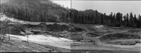
General view of rock quarry located 7 miles upstream on Vallecito Creek. Only a small quantity of rock remains to be excavated to complete the dam., Original photo number: Pine R - 213
-
-
Panorama of rock quarry (right)
-
General view of rock quarry located 7 miles upstream on Vallecito Creek. Only a small quantity of rock remains to be excavated to complete the dam., Original photo number: Pine R - 213
-
-
Panorama of spillway and river channels (left)
-
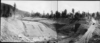
Panorama looking upstream at spillway and river channels from spillway station 30+50. Placing of drains and fine grading for concrete on vertical curve and stilling basin floor can be seen at left., Original photo number: Pine R - 412 a&b
-
-
Panorama of spillway and river channels (right)
-
Panorama looking upstream at spillway and river channels from spillway station 30+50. Placing of drains and fine grading for concrete on vertical curve and stilling basin floor can be seen at left., Original photo number: Pine R - 412 a&b
Pages
